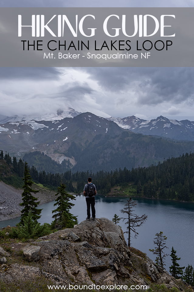
Hiking the Chain Lakes Loop | Mount Baker-Snoqualmie NF

Chain Lakes Loop| Written by Brian Callender | Photography by Julie Boyd

Chain Lakes Loop: Hike Details
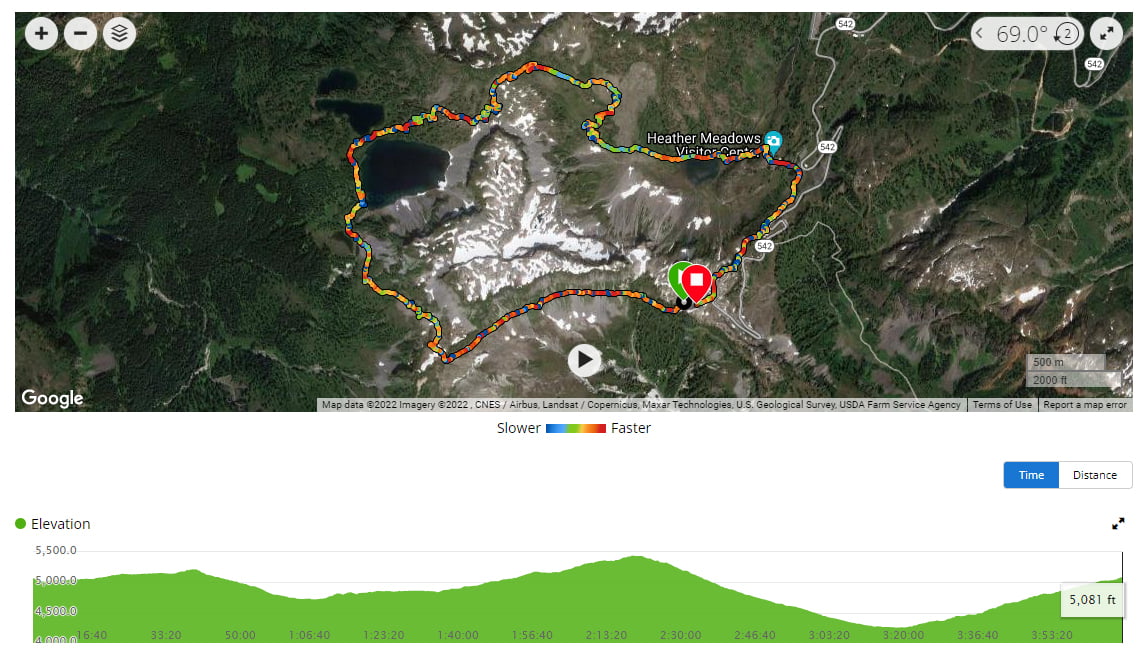
Starting Elevation: 4,250 ft.
Distance: 7.2 miles (hiking clockwise)
Elevation Gain: 1,837
Hike Type: Day-Hike
Difficulty Level: Moderate-Difficult
Food Storage: We didn’t come across any bear boxes, but this is a very popular trail and area, so it would be surprising to encounter a bear here.
Restrooms: Two pit toilets by the Visitor’s Center
Cell Service: Decent — we had the best service by the Heather Meadows Visitor’s Center and then sporadic service at other times.
Crowd Factor: Very high. This is one of the more popular hikes in the Mount Baker-Snoqualmie National Forest. It was slightly less busy for us because we started later in the day and rain was impending.
Parking: Plentiful, you’ll just need to decide where you park as it determines the end of your loop. On a warm summer day, it would be easy to see the parking fill up quickly.
Permit: For most hikes in Washington, you’ll need either a Northwest Forest Pass or if you have a National Park Pass, that works too. No permits are required for day-hiking.
Date Hiked: 9/4/2021
Every year, Julie and I plan a hiking trip for Labor Day weekend since it’s a holiday we both always have off from work. For this year, we booked a backpacking trip in the Eastern Sierra to one of the seemingly endless lakes that are on our to-do list. With what seems to be a never-ending reoccurrence in our state, the Forest Service decided to preemptively close the majority of forest land to minimize the impact of a possible fire. That meant our plans were cancelled and our options for rebooking a trip within a week were limited.
Rather than visit our tried and true destination, Yosemite, which I assumed would be packed with people in the same situation as us, I suggested something different. Fly to Washington and hike in the North Cascades. Washington had cooler weather, limited issues with fires (yup, we looked for places with less fires, because it’s hard to avoid them entirely!) and countless hikes to satisfy our need for adventure. I mapped out a few hiking options, booked a last minute flight using leftover points, grabbed a few hotels and we were off!
Getting to the Chain Lakes Trailhead

From Seattle, the drive to the Chain Lakes Loop Trailhead takes just under 3 hours. You’ll head north on I5 before picking up WA-9 near Burlington. WA-542 E near Deming will take you the rest of the way there. None of the roads are especially windy, which makes this is a pretty easy drive to the trailhead. Be sure to check road conditions any time you head into the mountains.
Hiking the Chain Lakes Loop
Arriving in the early afternoon, we found plenty of parking, but it is easy to imagine the lot being full on a busy day. Since we were getting a later start than normal, we opted to spend some time talking with a ranger inside the Visitor’s Center. She was very chatty and helpful, giving us plenty of recommendations, including starting the Chain Lakes Loop hike clockwise for the best views.
From the Visitor’s Center, we drove the remainder of the road to the parking lot near Artist Point and the Chain Lakes Loop Trailhead. If you’re doing the hike clockwise, this is where you will want to park. It’s a bit easier to start, but you’ll have to climb on the way out of your hike.

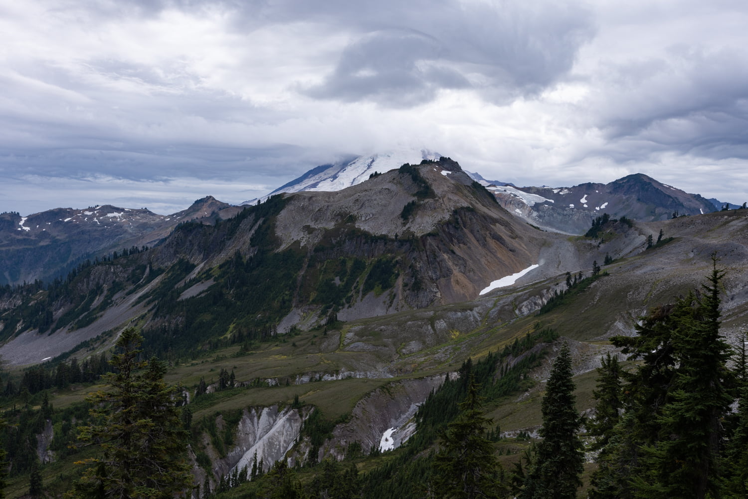
We parked, loaded up our packs and hit the trail, which dips down slightly, and then follows a mostly flat and slightly rocky ridge line for a little over a mile. You’ll reach a junction at 1.15 miles and want to stay right here towards Chain Lakes. The whole hike in, you’re staring right at Mt. Baker, which was pretty moody thanks to rain clouds hovering around it. Don’t forget to occasionally turn around for equally amazing views of Mt. Shuksan in the other direction.

After the junction, the trail descends quickly through a rocky open section. A short while later, you’ll head back into the trees. It’s still downhill as you make your way towards the lakes the first of which, Mazama Lake, comes into sight before the two mile mark. There is a short spur trail, if you want to go down to the lake, but we opted to keep moving. We saw several backpackers who had set up camp nearby and were relaxing near the lakeshore.
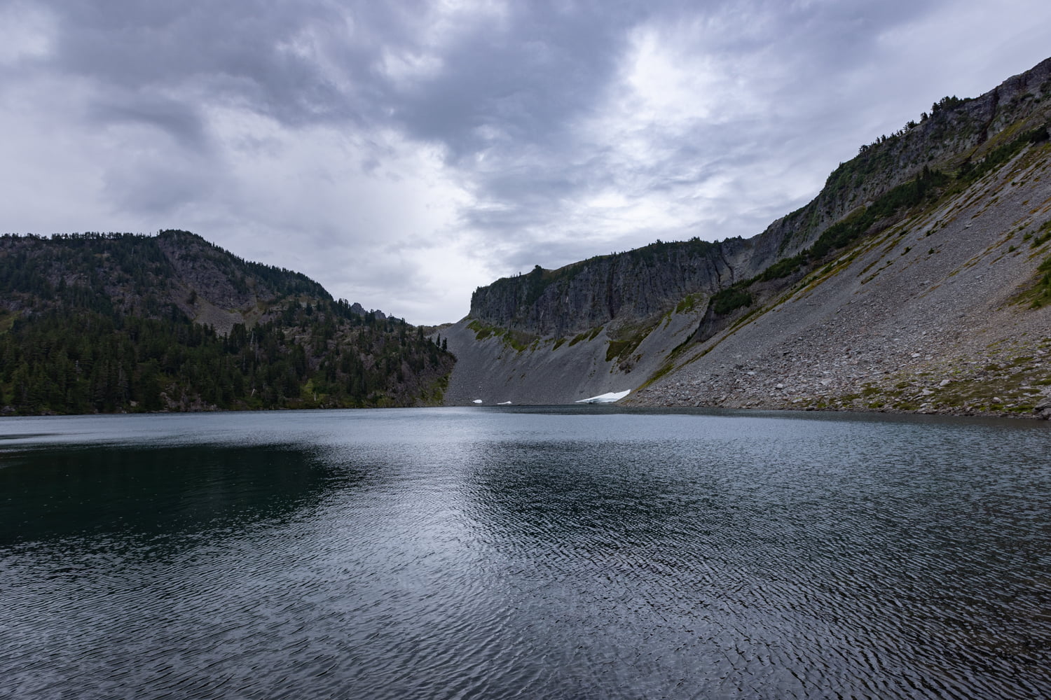
Once you pass Mazama Lake, the trail climbs slightly for a quarter mile before reaching Iceberg Lake. There are several easy places to access the lakeshore both immediately and a few feet further along. We stopped here for some photos and to throw on our rain jackets as a light drizzle had begun to fall.
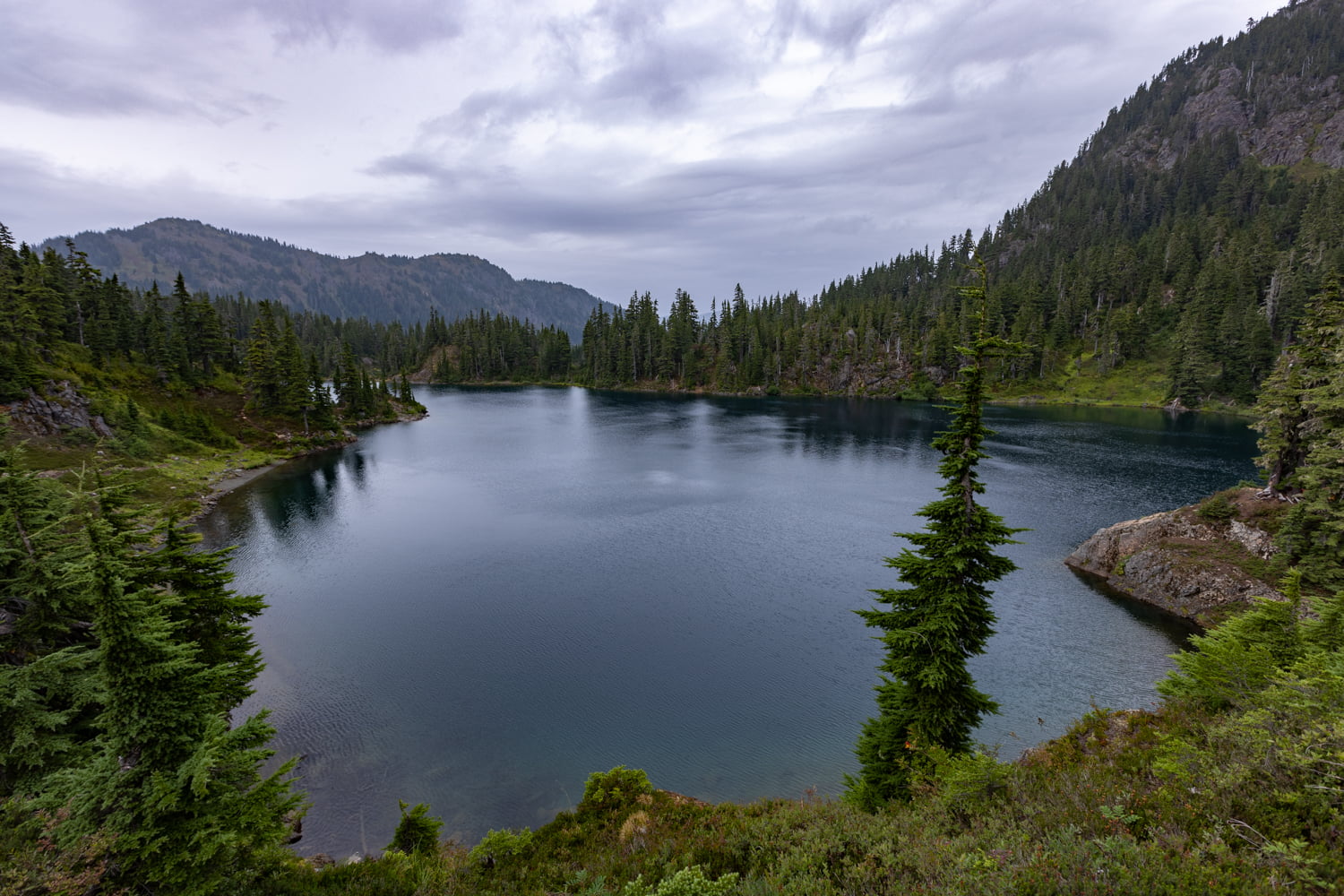
Continuing along the trail, it’s a short walk to Hayes Lake, another beautiful, deep blue lake. There are plenty of great vantage points to enjoy the lake from above and we also saw quite a few people camping closer to the shore. Up to this point, we hadn’t been sure whether or not we were just going to hike back the way we came or complete the full loop. Despite the late start, we both agreed that we would rather hike the loop, even if it meant getting back to the car in the dark (we always pack headlamps for this exact reason).
From here, the trail winds past Hayes Lake and then begins to climb with Iceberg Lake on your right. This next section is uphill through a lovely forested area. There’s a nice but somewhat obstructed view of Iceberg Lake again from above around 3.25 miles. You get a small bit of relief when the trail flattens out after the latest climb but it’s short lived as you approach the saddle. We took a little bit of time to enjoy the views of where we had just hiked up from, before we got ready to tackle the uphill section ahead of us.
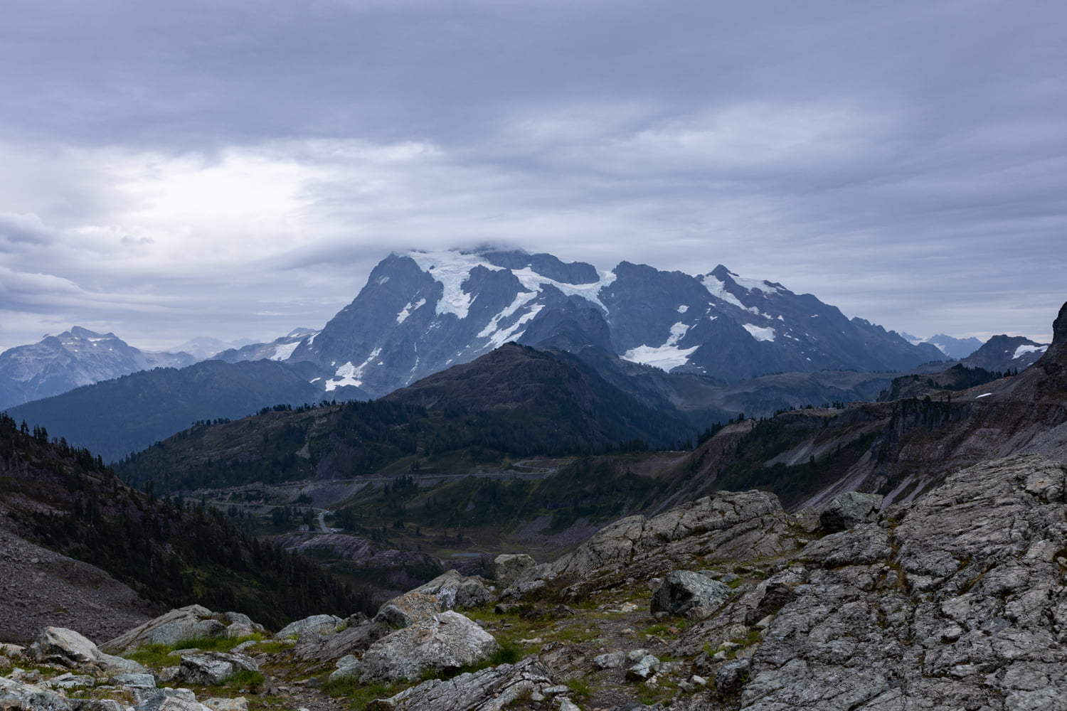
Once you reach the saddle the views in both directions are incredible. Having previously been on the fence about hiking the whole loop, we were immediately validated in our decision to continue once we reached the saddle. At the 4 mile mark, the trail begins its descent toward Bagley Lakes. Most of this section is quite rocky, so we suggest taking your time as it’s easy to lose footing.

Getting down to Bagley Lakes seemed to take forever, although it was only 1.65 miles. A small bridge crosses the southeastern outlet of the lake connecting you back towards the Visitor’s Center. It’s a climb up stone steps to get there, and we reached the visitor center at 6.2 miles.

After the visitor center, you’ll walk across the parking lot at the top of the hill and then connect up with the Wild Goose Trail. We were a little sad when we reached the Visitor’s Center because we had been parked here a few hours earlier, and knew we still weren’t done with our hike quite yet.

The Wild Goose Trail was interesting to say the least. This section is an uphill slog that covers a mile and over 800 feet of gain. There’s even a series of ladders that you’ll walk over as you climb. It was chilly and a bit rainy by the time we reached the top of the trail and just as the last light of the day was setting, we were back at the car.
Final thoughts on Hiking the Chain Lakes Loop

Our first hike in the North Cascades-Mt. Baker area did not disappoint and we were so glad we made the trip! It’s easy to see why this is one of the more popular hiking destinations in Washington and the Chain Lakes Loop was a great introduction. The hike itself is not especially difficult, although there is a good amount of elevation gained. If you’re looking for a hike with beautiful alpine lakes and stunning mountain views, you will definitely want to put the Chain Lakes Loop on your hiking list!
More Adventures From Washington
Fall Roadtrip through Washington
Shop our favorite gear for this adventure


Save this post for later