
Driving the Icefields Parkway | Alberta, Canada

Icefields Parkway Itinerary | Written by Brian Callender | Photography by Julie Boyd

Famous for its stretch of unmatched natural beauty, the Icefields Parkway travels between Banff and Jasper National Parks. The 175 mile drive derives its name from the Columbia Icefield, which feeds several glaciers that can be seen as you traverse through the area.
There are no shortage of points of interest to stop at along the parkway and you could spend months hiking on the parks countless trails. Read on to see our recommend Icefields Parkway Itinerary.

Lake Louise
Leaving from Banff, a 40 minute drive will lead to the first stop on the Icefields Parkway, Lake Louise. Here, you will find two of the more well-known lakes in Banff, Moraine Lake and the aforementioned, Lake Louise. Based on the enormous popularity of these lakes, be sure to arrive very early or later in the day to minimize the crowds. Some of our favorite hikes in this area include: Plain of Six Glaciers, Consolation Lakes, Lake Agnes and the Big Beehive.

Bow Lake
From Lake Louise, the drive to Bow Lake is a quick 23 miles. One of the things we loved most about the Icefields drive is the accessibility of all the sights. Bow Lake can be seen from the road, and it’s easy to pull over and enjoy the beautiful blue hues. If you have the time, there is a nice hike you can take to the Bow Glacier and the falls of the same name.

Peyto Lake
Just under 4 miles from Bow Lake, Peyto Lake is one of the big stars of the region. You can see Peyto Lake in pictures, but it’s something entirely different to witness its turquoise splendor firsthand. Named after Bill Peyto, an early trail guide and pioneer, the lake receives its famous color from the glacial rock flour that flows in. The color is most prominent in summer, but the lake looks good in any season! To enjoy the lake, take the short walk up from the parking lot to the viewing platform which looks out over the lake below.
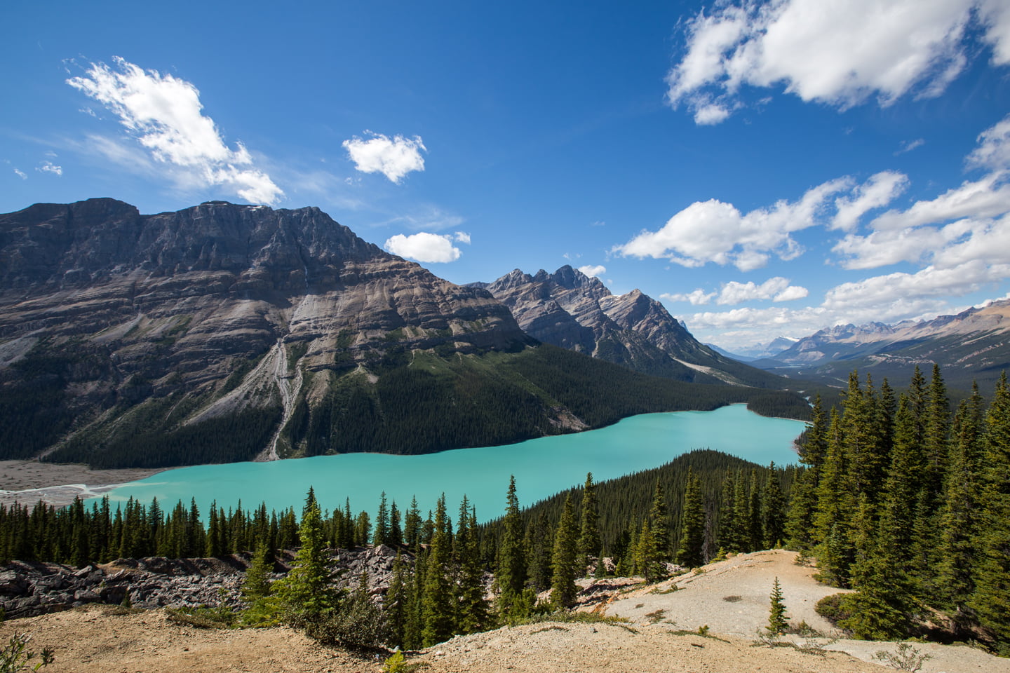
Tip: The Peyto Lake viewing platform is the most popular point to view the lake, but also the most crowded. If you’re like us, you’ll want to avoid the crowds. Before you reach the platform, make a quick right turn into the trees, which will lead you to a dirt overlook. Take in the views here, for as long as you like, it’s definitely a surreal sight! Icefields Parkway Itinerary

We later learned that there is a trail that takes you all the way down to the shores of Peyto Lake. On our next visit, we took the short trek to the lakeshore and had it all to ourselves!
Mistaya Canyon
From Peyto Lake, Mistaya Canyon is 18 miles north and a quick stop before you reach the Saskatchewan River Crossing. Formed by the Mistaya River, the canyon can be viewed via a short walk downhill from the parking lot. Here, the fast moving river has carved out some distinct curves, making the canyon a popular viewing point. As with any fast moving water, be sure to avoid the temptation to get too close to the river!
Tip: As you drive along the Icefields Parkway, it’s important to note that there is only one place to stop for gas and food. We stopped at the Saskatchewan River Crossing on our return from Jasper, but were sure to have a full tank of gas anyway as pricing can be as high as 50% over regular rates. Instead, we opted to enjoy and ice cream cone and take in the views! Icefields Parkway Itinerary

Big Bend/Big Hill Viewpoint
The next stop along the Icefields Parkway in Banff National Park is at the Big Bend/Big Hill lookout. This switchback, 42 miles from Mistaya Canyon, is a great opportunity to look back at the road you’ve traveled on and provides stunning views below. Look closely, and you can see Bridal Veil Falls in the distance!

Columbia Icefield
Our next recommended stop is at the Columbia Icefield, 10 miles north from the Big Hill/Big Bend Viewpoint. The Columbia Icefield is an extensive network of glaciers that date back to the last Ice Age. Located at the crossroads of Banff and Jasper National Parks, and alongside the Continental Divide, eight glaciers make up the Icefield. When you visit, the most prominent and visible glacier is Athabasca, which immediately catches the eye. We highly recommend booking a tour to walk on the glacier, which we did with local company, Ice Walks.


Tangle Creek Falls
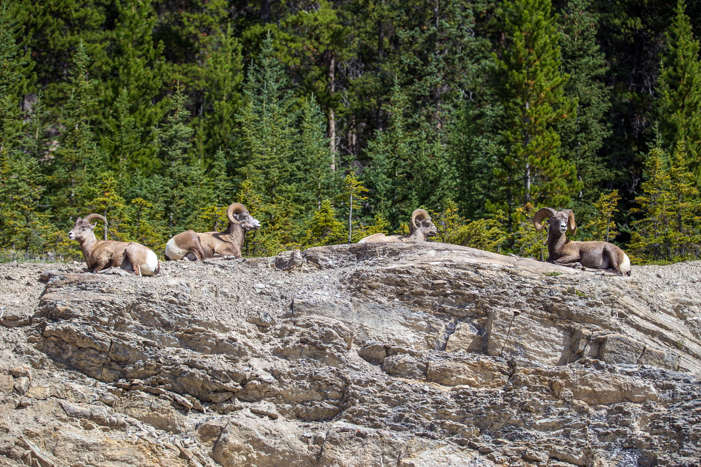
The next point of interest along the parkway is Tangle Creek Falls, which we completely missed on our first trip up to Jasper. It’s just 4 miles the Columbia Icefield Center, so be sure to keep an eye out for them. Tangle Falls are located alongside the road and was particularly crowded when we stopped as several bighorn sheep were lazing about nearby. A great feature about the falls is that you can get up close to them with a short and easy climb alongside them. We took a very short hike to the top of the falls which was well worth the extra effort.

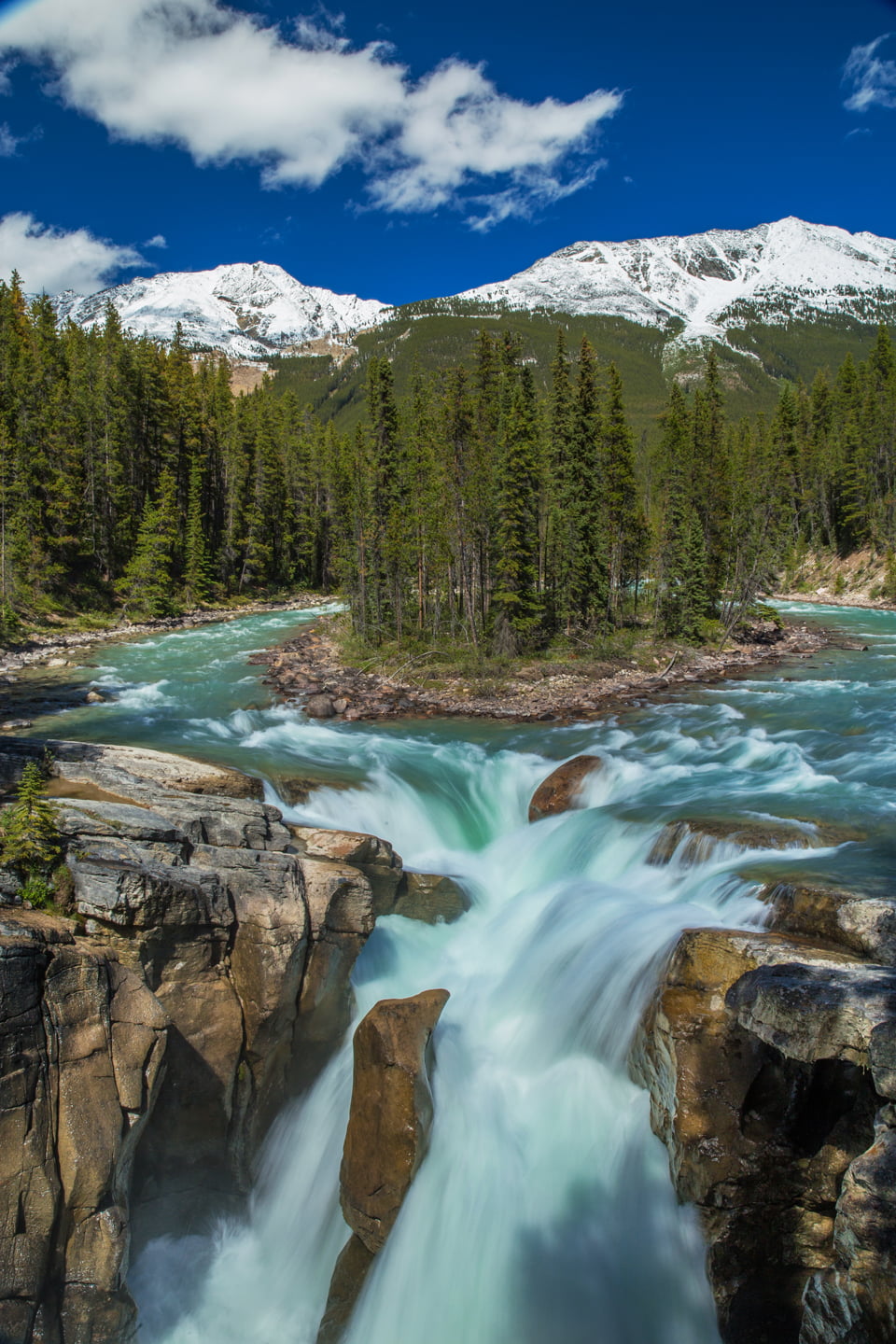
Sunwapta Falls
One of the more popular waterfalls on the Icefields Parkway, Sunwapta Falls, is the next stop. Just 25 miles from Tangle Falls, photographers flock to shoot these powerful falls with a small island in their center. As with all fast moving water, be sure to exercise caution when getting near the falls.
Athabasca Falls
Another 15 miles north on the Icefields Parkway is Athabasca Falls. Similar to Sunwapta Falls, Athasbasca is located a short walk from the trailhead just off the Parkway. The falls are particularly impressive due to sheer power and force that are produced by them. Several viewpoints let you get incredibly close to the falls and signs remind visitors not to get too close. The glacial water is unforgiving, so be sure to stay on the platform and avoid the temptation step out onto the slippery rocks.
.


Jasper
The final stop on the Icefields Parkway is the town of Jasper, 20 miles north of Athabasca Falls. Jasper has a more small town feel than Banff to the south, and during our visit, felt much less crowded. There are plenty of adventures to be had in the Jasper area and you can find some of our favorites in the links at the bottom of this post.
Bonus Trip
If you have extra time during your visit to Banff and Jasper, we highly recommend a side trip to Yoho National Park. Some of our favorite hikes there include: Twin Falls, Wapta Falls, and Takakkaw Falls. Icefields Parkway Itinerary

More from the Canadian Rockies
Hiking to Lake Agnes & the Big Beehive
Hiking Moraine & Consolation Lakes
Lake Louise and Hiking the Plain of Six Glaciers
Columbia Icefield Tour: Athabasca Glacier Hike
The Best Places to Visit in Banff
Recommended gear and trip planning resources


SAVE THIS POST FOR LATER!

those photos look unreal ! You must have time of your life driving there !
Thank you! Yes, we had an amazing time and can’t wait to go back and see and do even more!
Sounds like an amazing day. I’d say the Icefields Parkway is arguably the most scenic drive in North America.
It definitely was an amazing day and trip! I would agree, so far, I’d be hard pressed to find a better stretch of scenery.
Oh man, you got PERFECT weather for it! I never knew there was a trail down to the shore at Peyto, I’ll have to try and check that out! There are so many unbelievable places along there.
Thank you! Yes, the first time we visited, we did not see the trail. We’ll be back this week to explore more though. 🙂