
Hiking Mission Peak | Bay Area California
Hiking Mission Peak | Written by Julie Boyd | Photography by Julie Boyd
One of the things I miss the most about living in Southern California is the proximity to high altitude hikes in the San Gabriel Mountains. Sure, living in the Bay Area means that Brian and I are a 3.5 hour car ride away from the Sierra Nevada Mountains, but making that journey requires much more planning, and time. While searching for challenging Bay Area hikes that were also scenic, I came across the Mission Peak trail. In fact, several sources noted that many of the Bay Area REI locations recommend the trail as a training hike for Half Dome. Eager to get in shape for some of our summer backpacking trips, Brian and I set our alarms to wake up extra early one Sunday morning, and hit the trail.
Hiking to Mission Peak: Hike Details
Starting Elevation: 522 ft.
Distance: 6.20 miles (official distance is 5 miles, but we always ad-lib on our hikes)
Elevation Gain: 1,995 ft.
Hike Type: Out and back, day-hike
Difficulty Level: Strenuous
Date Hiked: July 13, 2018
Getting to the Mission Peak Trail
It turns out that most challenging part of hiking Mission Peak is finding a parking spot. There is a small parking lot (about 40 spaces) at the end of Stanford Avenue in Fremont, and Brian and I thought that we would be able to snag a spot when we arrived at 8:00 a.m. We were wrong. The lot was full. The Streets were full. It was madness. Luckily, during my research I read that there was another trailhead, so after circling through the traffic, we made our way to the Ohlone Trail.
To access this alternate trailhead, simply backtrack to Mission Blvd, hang a right, and make another right on Pine Street. This will take you back to the Ohlone College parking structure, which has ample parking on the weekends. Don’t forget to purchase the $4 parking permit from one of the machines before you set out. The trailhead is well-marked, and is located just across the street from the parking garage.
Hiking Mission Peak
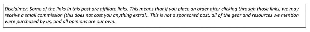
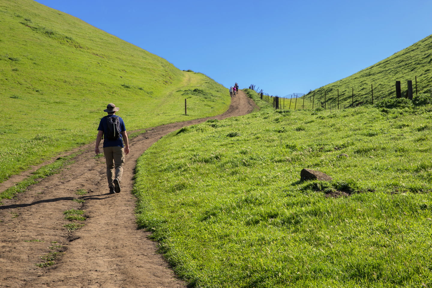
The Ohlone trail is about 1.5 miles longer than the trail from Stanford Avenue, but that means that the 2,000 ft ascent is more gradual. The direct route was our preference since we were hiking to train, but this route was also a good workout, and we were glad to have a covered parking spot. The entrance to the trail is marked by a cow gate, and do note that you will be sharing the route with bovine that are grazing along the rolling green hillsides. Remember to respect their space, and keep an eye out for cow pies, and you’ll be just fine.
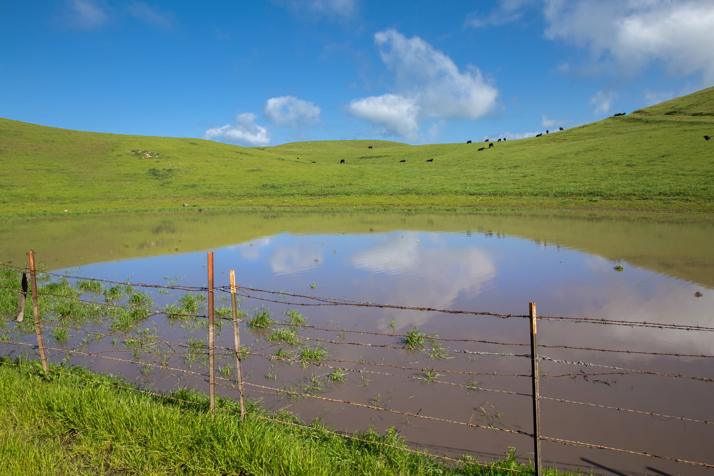
The beginning of the hike is fairly gradual, along a broad, dirt fire road. After about a mile, you will pass a pond, and then head into a shaded section of single-track trail. On sunny days like ours, it was a welcome stretch of trail. After you emerge from the trees, the path really begins to climb, and then about a half-mile later the trail flattens out more, and your goal finally comes into view.
.

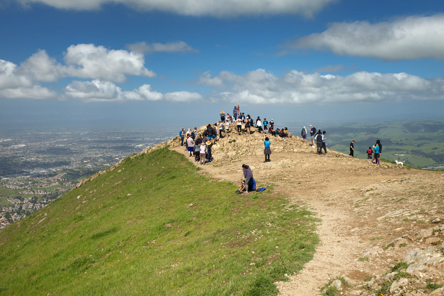
The trail then intersects with the hikers coming up from Stanford Avenue, and becomes much more crowded. Note that at the junction there are some benches and a pit-toilet. From here, you begin heading up another steep section, and during the last quarter-mile the fire road ends, and the trail becomes a rocky-single track. There was a bottleneck of people coming up and down at this point, and many hikers choose to veer off trail and create their own route.

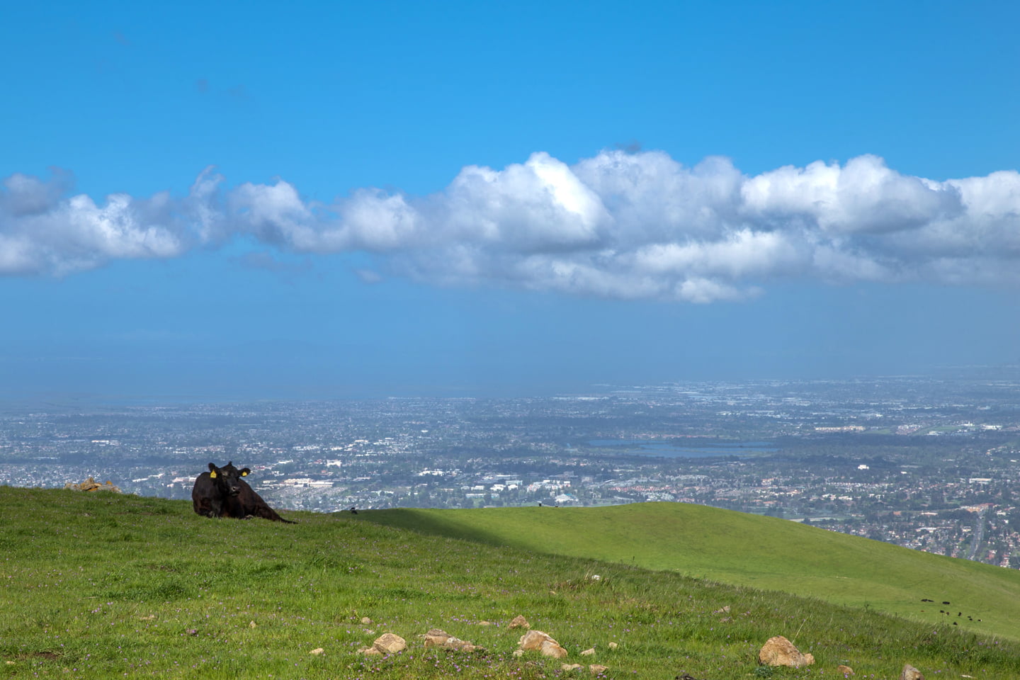
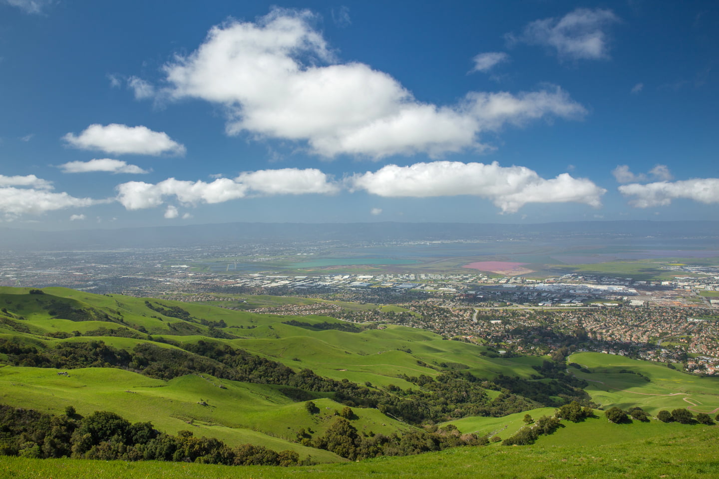
At the top, we were rewarded with 360-degree views of the Silicon and Central Valleys. Many hikers lined up to take a photo of the monument on the summit, but we decided that enjoying lunch solo would be preferable.
After chowing down and taking in the views, we headed back to our car. While hiking Mission Peak wasn’t as exciting as being in the San Gabriel Mountains, we enjoyed exploring a new trail and getting a good workout in at the same time.
Have you been on the Mission Peak hike? Are there any Bay Area hikes that you recommend? Let us know in the comments below.
More Northern California hikes:
Hiking Glacier Point, Dewey Point, and Sentinel Dome
Hiking to Upper Yosemite Falls
Hiking to Castle Dome, Shasta-Redding
Our favorite Gear for this hike:


SAVE THIS POST FOR LATER!

I am dying to go back to Cali and exploring more! Will add this trail to my list. xo, natalie http://nataliastyleblog.com
There are a lot of great place to see here. 🙂
I think I have heard of a lot of people doing this hike. Nice to hear about places to hike near me. I will definitely need to check this one out!
It is one of my favorite Bay Area hikes so far (we move dup here last year). If you do it in summer, be sure to get an early start because it is very hot and there is not much shade.
What a beautiful day for a hike! I love the green rolling hills, looks like you had a great day out! Thanks for sharing such a helpful guide 🙂
It was definitely a beautiful day! Thanks for checking it out!
Never been on the Mission Peak hike. Such a lovely green meadow and a clear blue sky! Definitely, hiking is the best way to enjoy the extreme natural beauty around. Cool photos!
I agree! Hiking is my favorite was to enjoy the outdoors.
Those cows are so sweet! Looks like a really awesome hike=thanks for sharing.
You’re welcome! Thanks for stopping by!
We’re heading to Southern California later this summer, so I’ll definitely try to fit this in. Looks like an awesome hike. Your pictures are amazing — those cows!!
This hike is actually in the Bay Area (Northern California). We have posts about a few Southern California hikes on our “Hiking” page if you are looking for hikes to do during your visit.
Wow! Thanks for sharing this one! I will do this on a weekend soon. Love all the green and the view in your pics.
Parking our car in the parking lot is a struggle always! How I miss public transport here especially after living in Switzerland for 6 years.
Thank you! Unfortunately the hills have all turned brown now that it is summer, so I recommend doing this one in the winter or spring after we have had some rainfall. Switzerland has great public transport. Brian and I were just talking about how the trains were always on time, as we waited for a late train to take us into San Francisco for the day. Lol.
I would love to do a hike in a Cali and this one sounds amazing! Such a pity about parking — that’s always a downer. But I guess you can overlook that with such incredible views
Yes! Luckily the alternate lot has plenty of parking. You can also try to get there earlier than we did. Lol.
I love the bay area in general! I was in SF a few weeks ago got to see some incredible views. I didn’t visit mission peak though. So I’ll be saving this for the future.
Is it weird that my favorite part about this hike is that you share the trail with cows?! How adorable are they? Cowpies…not so much haha